2. THE INVESTIGATION METHODS
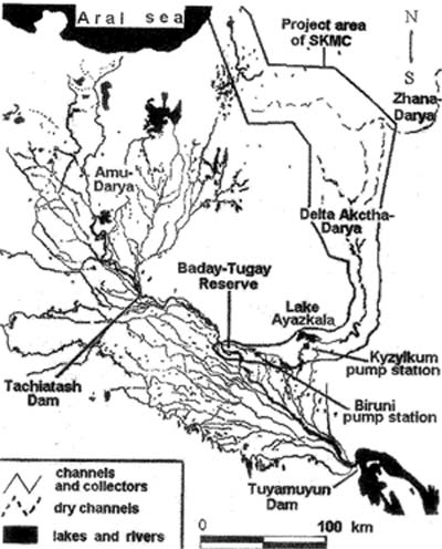
The vast area affected by the SKMC was divided into four regions according to physiographic conditions: (a) coastal plains of the Aral Sea including the dried sea floor, (b) the old Zhana-Darya and Akcha-Darya channels and delta, (c) the zone of influence exerted by discharged waters in the area near the Ayazkala lake and (d) the «Badai-Tugai» nature reserve with adjacent tugai1 and agricultural lands.
Monitoring of salinization of surface and ground waters, groundwater depth, the state of plant and soil cover, and bird populations was undertaken to assess the impacts of the Collector upon the environment and ecosystems. Through examination of sociological and economic indices for a long period of time it was also possible to estimate the damage that would be caused to the native population. The data obtained in the course of long-term scientific observations in the Amu-Darya delta provided a basis for assessment of ecological and social consequences in all four of the defined regions.
3. CHARACTERIZATION OF ECOSYSTEMS IN THE PROJECT AREA
In the zone of influence of waters discharged into the Akcha-Darya old channel (wetlands, Figure 12-2) and in the area near Ayazkala lake (lake banks and adjacent plain) hydrophytic2, halophytic3 and tugai vegetation is developed.
The unstable vegetation is localized, being mainly represented by ecotone communities: (a) hydrophytic vegetation — Phragmiteta australiae, Typheta angustifoliae and Bolboschoeneta maritimae, (b) halophytic vegetation —Halostachydeta belangerianae, Salsoleta dendroidis, Lycium ruthenicum, Climacoptereta aralensis, Suaedeta salsolae, etc. (c) tugai ecotone halophyte complexes — shrubs such as Tamariceta hispidae and grasses (Karelinieta caspicae, Aeluropideta littoraliae), tugai.
In the region of the Akcha-Darya old channel and delta and the Zhana-Darya old channel typical desert vegetation is dominant in automorphic [153] territories: (a) psammophilous shrubs on desert soils of hilly and hilly-ridged sands (Haloxyleta persicae, Ammodendreta conollis, Calligoneta caputmedusae, C.aphyllae, Salsoleta arbusculae) together with grass species: Carex physodes and Stipagrostis karelinii (b) shrubs and grasses on takyr4 soils of the old delta plain (in depressions): Haloxyleta aphyllae, Anabasieta salsae, Climacoptereta lanatae.
As a whole, the floral list includes 125 species of higher plants in the regions under study.
The Badai-Tugai nature reserve, with adjacent lands, occupies a rather small area but it is most important for preserving biodiversity in Central Asia. The nature reserve was formed to preserve the disappearing floodplain intrazonal tugai ecosystems. Because of regulated river flows everywhere in Central Asia and conflicts in Tajikistan and Afghanistan, the Badai-Tugai nature reserve (6 000 hectares) may be considered as one of the last remaining areas of tugai vegetation in desert plains. It is inhabited by bukhara deer, wild-boar, khiva pheasant, bustard, fox, jackal, badger, tolai hare, etc. There are more than 70 kinds of birds and 10 kinds of amphibian and reptiles (Kouzmina & Treshkin, 2001).
Within this nature reserve, four vegetation types, developed under hydromorphic and semihydromorphic conditions, can be distinguished: (a) arborescent tugai (Populeta arianae, P. pruinosae, Elaeagneta turcomanicae), (b) shrubby tugai with its distribution linked to salinization of soils and ground waters (Tamariceta ramosissima, Tamariceta hispidae), (c) grassy tugai (Alhagieta pseudalhagii, Aeluropideta littorales, Glycyrrhizeta glabrae, Phragmiteta australiae and Trachomiteta scabrii), (d) widespread solonchakous5 vegetation: Halostachydeta belangerianae, Salsoleta dendroidis, Climacopterteretalanatae, Suaedeta salsolae, etc. (Kouzmina & Treshkin, 2001; Novikova et al., 1998, 2001; Treshkin, 2001).
The ecological state of the ecosystems may be divided into three types: relatively well preserved (20%), at different stages of desertification (50%) and completely desertified ecosystems (30%).
4.ECOLOGICAL SITUATION IN THE AREA NEAR AYAZKALA LAKE
Ayazkala lake has an anthropogenic origin (Figurel2-2). In the 1980’s it was artificially created among typical sand deserts as a reception basin for drainage water. [154]
The banks of the western saline and stagnant part of the lake (Figure 12-2) are covered by sparse solonchakous vegetation of little use for cattle (Suaeda salsa, Halostachys helangeriana, Tamarix hispida, Climacopters lanata). This vegetation began to appear after construction of the lake. The typical productive pre-existing psammophytic vegetation was degraded to a considerable extent. Higher groundwater levels caused the disappearance of such typical desert grass-shrubby communities as Haloxylon persicum+Ammodendron, conolly+Calligonum, spp.+Salsola arbuscula-Carex physodes, and they were not replaced by productive tugai complexes. Due to higher salinity in this part of the lake the banks are covered by a thick salt crust, remain bare, and solonchakous vegetation is rare. Therefore this artificially formed lake serves as a focus for salinization. In addition to ground salinization of adjacent areas, aeolian salt transfer takes place, thus reducing the productivity of nearby agricultural lands.
The banks of the eastern influent and slightly saline part of the lake (Figure 12-2) are covered by Phragmites australis and Phypha angustifolia in strips (1-3 m wide), which are not of economic or environmental value.
The floristic composition of adjacent lands, including typical sandy, solonchakous vegetation with admixture of tugai is very poor and contains only 35 species of higher plants.
In connection with the construction of the South-Karakalpakian collector, the Kyzyl-Kum drainage pumping station will be closed and Ayazkala lake will be entirely drained. Therefore the degradation of typical sand desert ecosystems through high groundwater and salinization will be stopped and the regeneration of degraded sand desert vegetation will help the formation of rangelands suitable for some cattle. Moreover, there will be no salt accumulation in the lake and closing of the drainage pumping station will save money that can be diverted to other purposes.
Changes in the ornithological complex and the increase in salt transfer from the dried bottom of the lake may be considered as possible negative consequences of this transformation, because additional investment will be required for rehabilitation of the dried lake bed.
However, it is feasible to prevent salt transfer by means of biological rehabilitation of lands. As seen from data obtained in Ben-Gurion University (Israel) and in Turkmenistan, some salt-tolerant plant species can be intensively grown and developed on the dried lake beds if planted by special methods. For instance Haloxylon planted on saline soils under irrigation with the sea water (Nebitdag desert station in South-Western Turkmenistan) revealed good root formation. Thus, the problem of salt transfer in the dried bottom of Ayazkala lake may be successfully solved. [155]
In view of the low water level in the Amu-Darya river (1999-2001) the local fishery declined by a factor of 20, and self-restoration is impossible in the near future. Within the period 1998-2002, catches decreased from 10 tons to 500 kg per month. Following the disappearance of fish in the lake 85% of the inhabitants have left Ayazkala settlement and only 10-15 people are now engaged in fishing. Therefore the consequences of the disappearance of this lake for fisheries will be minimal.
5. ECOLOGICAL SITUATION IN THE REGION OF THE AKCHA-DARYA OLD CHANNEL AND DELTA
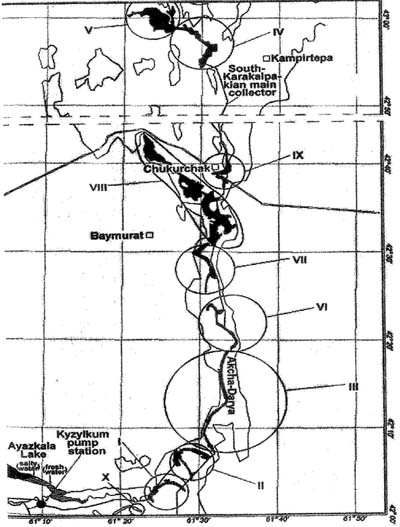
Along the Akcha-Darya channel (Figuress. 12-1, 12-2) are Haloxylon plantations of higher bonitet6. The plants are rather tall (1.5-4.5 m) and are 6-20 years old. Haloxylon aphyllum occupies takyr-like soils and solonchaks, while Haloxylon persium occurs only on sands. The collector water floods to form wetlands covered by hydrophytic vegetation (Figure 12-2). In the periphery of the wetlands there is a narrow unstable strip (1.5-7 m) of halophytic-solonchakous vegetation and/or tugai ecotone halophyte complexes.
The Akcha-Darya old delta and Zhana-Darya old channel display peculiar features, which are as follows: solonchakous vegetation consisting of Halocnemum strobilaceum and Halostachys belangeriana so specific to solonchaks in the southern dried part of the Aral Sea (region (a),Figure. 12-1); vast bare areas of takyr-like soils; and near absence of tugai complexes due to a high degree of soil salinization.
Stipulated by the plan, the average water discharges in the collector are 23 m3/sec and the forced water discharges — 40 m3/sec, being estimated to 23 m3/sec near Chukurkak settlement. In the central part of SKC (42° 16′ — 42°45′,Figure. 12-2) the relief is highly dissected. When wetlands III, VI, VII, VIII, IX are formed by discharged water, the depressions between ridges in the adjacent sand desert will become flooded to form small lakes. As a consequence, the productive psammophyle vegetation suitable for grazing of sheep and camels will become degraded. Depressions with stagnant water will promote the reproduction of blood-sucking insects, which are dangerous for sheep and camels; as observed in this region in 1998. [156]
All of the wetlands are covered by hydromorphic vegetation of the same type. Phragmiteta australiae and Typheta angustifoliae can be of use for cattle, however the cattle-breeding is practically absent here. The region is scanty populated. The inhabitants of Baimurat, Chukurkak and Kempartobe settlements are engaged in farming sheep and goats as well as camels (more than 22000 head), but the above vegetation is unsuitable for these animals. Ayazkala settlement is also small, consisting of only 40 families. Therefore increased live-stock farming should not be expected after the formation of wetlands III, VI, VII, VIII (Figure 12-2). It is also impossible to develop the fishery because of the high content of salts in collector waters. It is evident from 1998 test flooding of the Akcha-Darya channel that water was unsuitable for drinking in five drainage holes, because its salinity was increased to 2.1 g/1. Also, five pastures located along the collector became degraded. Due to rising groundwater the typical productive psammophilous vegetation including Ammodendron conolly, Salsola arbuscula, Calligonum caput-medusae, Calligonum aphyllum, Haloxylon persicum dried, and bare solonchaks were formed.
To be able to prevent the sand accumulation in collectors, local wild plant species should be grown along them and adjacent territories in strips 300-500 m wide. Such plants reveal good root formation, and are more tolerant to salinization and the greater fluctuations of groundwater level compared to cultivated plant species. In every region the trees and shrubs for planting should be selected with regard to soil salinization and the groundwater depth preferences (Kuz’mina & Treshkin, 2004; Pankova et al., 1994). Planting to a distance of 500 m from both sides of collector channels will prevent sanding and seepage loss of water.
6. ECOLOGICAL SITUATION IN THE BADAI-TUGAI NATURE RESERVE
Typical relict tugai ecosystems that remain here are practically absent in the lower reaches and delta of the Amu-Darya river (Kouzmina & Treshkin, 2001).
Created in 1973, the nature reserve contains nearly 167 species of higher plants, including 35 families and 120 genera. However, this list includes all the species of typical desert and solonchakous vegetation that are widespread only in the protected buffer desert zone (1362 hectares). In floodplain tugai areas, embracing 5929 hectares, there were only 90 plant species.
In 1985 the tugai flora list declined to 61 plant species. (Kouzmina & Treshkin, 2001). Hydrophytic and mesophytic vegetation disappeared as a [157] result of anthropogenic xerohalophytism. After constructing Tuyamuyun (1980) and Takhiatash (1974) hydro-electric stations (Figure 12-1) the water level in the Amu-Darya river fell by 4.0-4.5 m over 25 years (Kouzmina & Treshkin, 2001; 2003). River water taken for irrigation and functioning of the Tuyamuyun storage lake was a destructive factor for the nature reserve, because the water intake was more than 30% (500-800 m3/sec) of monthly water discharge.
Changes to environmental conditions in the Badai-Tugai nature reserve include cessation of floods required for maintenance of water levels, salinization of soil cover becomes salinized (1.6-4.5%7), fall in groundwater level by about 5 m (Kuz’mina & Treshkin, 1997), dead wood (40-50%), stag-headedness8 (55%), water heart9 (70%) occur, and there is no regeneration of wood and grass regeneration.
Monitoring of seasonal salinization and groundwater depth in 21 holes established that the ground water level is affected by the Kok-Darya tributary to a greater extent than by the Amu-Darya river. The influence extends about 1000m perpendicular to the river channel, whereas that of the Amu-Darya extends about 600 m perpendicularly from the channel. This can be explained by peculiar relief, notably a high natural levee near the bank of the Amu-Darya river.
Groundwater level dynamics studied in drainage holes indicates that landscapes in the central part of the nature reserve are now developed under automorphic conditions (GWT 5-5.5 m and more). Therefore ecotopes atypical of tugai ecosystems develop because the groundwater level does not meet optimum requirements for maintaining the tugai floodplain ecosystems (Kouzmina & Treshkin, 2003).
According to the main version of the project for SKMC construction either Biruni pumping station should be closed or the quantity of discharged waters should be partially decreased without improving the water quality. If so, the Kok-Darya tributary that replenishes ground waters through most of the Badai-Tugai nature reserve will entirely dry out or its flow will be reduced by two times. In different seasons of the year water salinization reaches 4.6-13 g/1 in Kok-Darya. Low discharge in the Kok-Darya channel as well as complete drying can cause irreparable damage to the nature reserve. In the first case, the central and northern parts of the nature reserve would be gradually dried, resulting in disappearance of forest stands. Complete drying of the Kok-Darya channel could cause the same areas to be dried at once. The loss of major tugai ecosystems would differ only in time: either in 1/2 or in 10/15 years. [158]
The scientifically-based version of a project to change water impounded in the Кок-Darya tributary differs from that connected with the SKMC construction and financed by World Bank. According to this, Biruni pumping station would continue to convey fresh water from the Amu-Darya river through existing collectors into the Кок-Darya tributary to be subsequently pumped over the territory of the nature reserve for the next 20 years (maximum water discharge would be 15 m3/sec up to 30 m3/sec). This would improve the quality of water pumping by the Biruni station, from 4.6-13 g/1 (at the present time) to 1-2 g/1 (in future).
This alternative version of the project would not require additional money or construction but would not reduce overall costs of the SKMC scheme. The improved quality of discharged waters in the Kok-Darya tributary would be conducive to decreasing soil salinization and groundwater level near the channel as well as to creating a stable regime for wood tugai ecosystems. The food base for bukhara deer and pheasant would also be improved. It will be possible to preserve the hydrological regime over the whole territory of the Badai-Tugai nature reserve and the groundwater level under tugai forests at a depth of 2.0-3.0 m in the growing seasons. It would favour natural tugai regeneration over more than 2000 hectares of solonchaks, which would be dissolved thanks to this project. Dull landscapes of solonchaks could be transformed into high-productive tugai ecosystems with the whole associated fauna complex.
7. ASSESSMENT OF PERMISSIBLE ECOLOGICAL CONDITIONS FOR HYDROMORPHIC TUGAI AND SOLONCHAKOUS ECOSYSTEMS
The authors’ long-term field and stationary investigations make it possible to evaluate the permissible groundwater level, the degree of salinization and the conditions favourable for different tugai and solonchakous ecosystems in the delta of Amu-Darya river including tugai complexes in zones of drainage water in the old course of Akcha-Darya, the Zhana-Darya and Badai-Tugai nature reserve.
• The permissible groundwater level, the degree of salinization of soils and ground waters reveal high fluctuations for various communities and different-aged stages of tugai ecosystems.
• Groundwater levels of 0.5-1.5 m are required for plant communities such as Salix songarica, Calamagrostis dubia, Phragmites australis, Typha angustifolia, T. minima, and T. laxmannii. For communities of Salix [159] songarica and Calamagrostis dubia the soil salinization and the groundwater level should be minimum within the first three meters -0.1-0.3%7 in soils and 0.8-1.2 g/1 in the ground water.
• A groundwater level of 2-2.5 m. is required for Populus ariana, Populus pruinosa, Elaeagnus turcomanica, Tamarix ramosissima, Halimodendron halodendron and for grasses such as Trachmithum scabrum, and Glyzyrrhiza glabra. Taking into consideration the unfavorable conditions in the Badai-Tugai nature reserve a groundwater level fluctuating from 2.5 to 3.5 m. is recommended (depending on the water amount in the river, the season of the year and the relief) for all wood-shrubby communities. This is the maximum permissible value of the groundwater level for maintaining the tugai ecosystems. Soil salinization under such plant communities can be rather high only in the uppermost metre layer — 0.8-1.5%7. The salinization decreases with the depth reaching 0.1-0.7% in the second and 0.05-0.6% in the third metre layer. Wood-shrubby communities can become dried when the soil salinization makes up 0.9-l%7 at a depth of more than 3 m. However, they can grow and develop in local salt-affected soil horizons (20-40 cm) at a depth of one metre (6-16%).
• The groundwater level in 3.5-4.5 m is tolerable for:
• solonchakous vegetation consisting of Tamarix hispida, Lycium ruthenicum, Salsola dendroides, Halostachys belangerian, Limonium otolepis, Suaeda salsa, and Climacoptera lanata. These are tolerant to soil salinization equall to 1.6-4.5%7 in the first two metres of the soil layer and 9-23% in some surface horizons (10-20 cm); in the third metre layer the soil salinization falls to 0.5-0.7%7 Plants grow when the salinization of ground waters fluctuates from 4 to 20 g/1.
• Grass communities, replacing former forests, comprising Alhagi pseudalhagi, Karelinia caspia, and Aeluropus littoralis are found to be tolerant to soil salinization of l-2%7 in the first two metres and the salinization of ground waters — 1-3 g/1.
• For seed regeneration of plant communities, surface flooding is required for 10-15 days in the period of fruiting, subsequent the maintaining the groundwater level at a depth of 0.3-0.5 m for a month. In this case, salinization should not exceed 0.05-0.07%7 in the first two metres of the soil. For Lochmium the soil salinization degree can be somewhat increased to 0.1-0.15%1 in the first two metres. The optimum degree of salinization of ground waters in the range of 0.7 — 0.9 g/1 is found to be favourable for the activity of shrubby young growth in tugai wood. (Kuz’mina & Treshkin, 1997; Kouzmina & Treshkin, 2001; Novikova et al., 1998). [160]
8. CONCLUSIONS
Our studies have shown that the artificially formed lake Ayazkala is rather poor in flora and fauna. The lake habitat for fish and birds is now highly degraded. Today’s ecological situation may be considered as critical. There are two possibilities for tackling this problem. The lake can be entirely drained for regeneration of the former sand desert vegetation and rehabilitation of the salt-affected bottom. Alternatively, the lake must become desalinized for regeneration of shrub and grass tugai, the latter being most important for increasing the lake productivity for fisheries and as a habitat for birds. It is inexpedient, from a scientific viewpoint to leave the lake in its present condition, because the lake and adjacent territories will continue to suffer from degradation.
As to the region of the Akcha-Darya old channel and delta, 25-40 m3/sec of water discharge, would lead to surface flooding of depressions between ridges in the desert. As a result, range lands would become degraded, and stagnant lakes would form and encourage numerous blood-sucking insects.
The least damage to ecosystems could be secured by deepening the collector channel without accompanying wetlands.
Aeolian sanding of collectors and seepage loss can be prevented by growing local tree and shrub species in wide strips along the collector channel.
When the South-Karakalpakian Collector is constructed the local population will be deprived not only of range lands located in the channel and near it, but drinkable artesian water in the area along the collector.
The problem of preserving the Badai-Tugai nature reserve after construction of the SKMC must be solved by regeneration of ecosystems through hydrotechnical measures designed to create environmental conditions similar to natural ones.
S.Y. Treshkin, Institute of Bioecology, Uzbek Academy of Sciences, Berdacha pr. 41, 742000, Nukus, Uzbekistan
ZhannaV. Kuz’mina, Water Problems Institute, Russian Academy of Science, 3 Gubkina St., 119991 Moscow, Russia
Notes:
1 Tugai is a floodplain forest of river valleys of Central Asia. Tugai’s are a unique type of ecosystem. It must be considered as a natural reserve of peculiar flora and fauna. In tugai vegetation prevail such species as: Populus diversifolia, P. ariana, P. pruinosa, Elaeagnus turcomanica, E. orientalis, Salix songarica and bushes from Tamarix genera.
2 Hydrophytic vegetation (hydrophytes)- the vegetation growing on wet soils.
3 Halophytic vegetation (halophytes) — the vegetation growing on saline soils.
4 Takyr — clay soil of deserts, often is saline.
5 Solonchakous — soil having very higher salinization, more than 1% (in percentage of salt).
6 Bonitet of forests — qualitative assestment of economic productivity of a forest. Bonitet depends on natural conditions and antropogenic impact on forest. There are five classes of bonitet. The basic parameter of bonitet is average height and diameter of trunks of trees in the certain (comparable) age.
7 Weighted average at a depth of 100 cm in percentage of salt.
8 Stag-headedness — dry top of trunk trees.
9 Water heart is disease (rotten stuff) of part trunk of tree.
GEOLOGY AND ECOSYSTEMS
International Union of Geological Sciences (IUGS)
Commission on Geological Sciences for Environmental Planning (COGEOENVIRONMENT)
Commission on Geosciences for Environmental Management (GEM)
Edited by Igor S. Zektser 2006
Library of Congress Cataloging-in-Publication Data Geology and Ecosystems / edited by Igor S. Zektser